
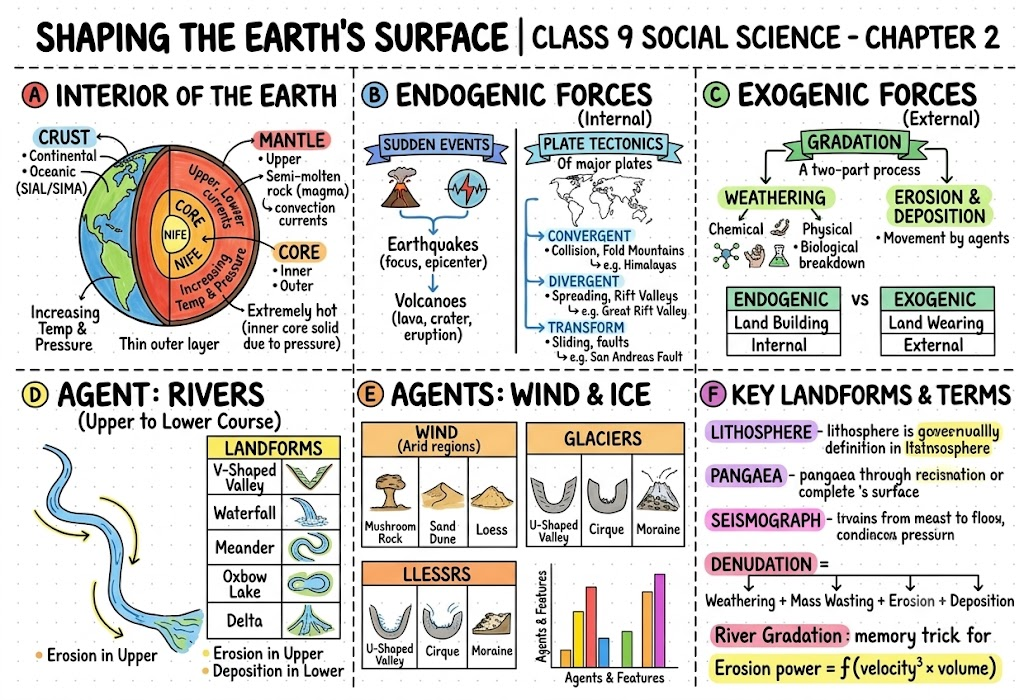
1. Introduction
Our planet’s outer surface never stays the same for long. It is being reshaped continuously by two kinds of forces — those working from deep inside the Earth and those acting on top of it. The idea that ties all of this together is plate tectonics, which tells us how huge slabs of the Earth’s crust glide very gradually over the soft, partly-melted layer beneath them. As these slabs shift, they give birth to mountains, volcanoes, plains, and valleys. Grasping plate tectonics and landform-building helps us make sense of earthquakes, eruptions, and even how continents and oceans came to be positioned the way they are.
Imp points to remember:
- A landform is any natural feature on Earth’s surface produced by weathering, erosion, deposition, or crustal movement.
- Mountains, valleys, plateaus, plains, deserts, and coastlines are all examples of landforms.
2. Plate Tectonics
The theory of plate tectonics, proposed by W.J. Morgan, explains why the Earth’s crust is never at rest. According to this theory, the crust isn’t a single unbroken shell — it is split into a number of large and small fragments known as tectonic plates. These plates creep along over the semi-molten layer under them, and their motion is behind major natural events such as mountain-building, earthquakes, and volcanic activity.
2.1 Layers of the Earth
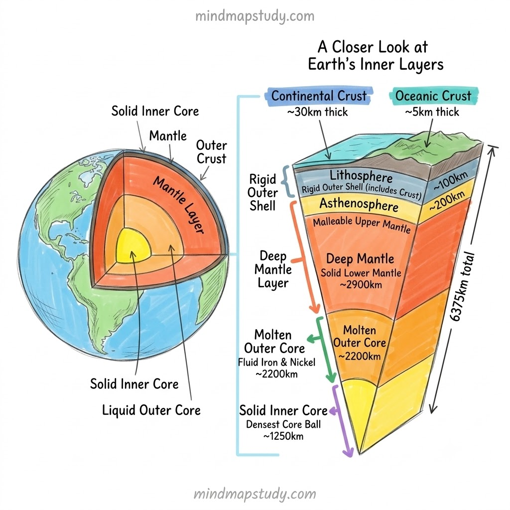
The Earth’s inside is made of three broad layers:
| Layer | Description |
|---|---|
| Crust | Outermost layer, the one we live on |
| Mantle | Thick, extremely hot layer below the crust |
| Core | Innermost layer, very hot and dense |
- The crust plus the topmost part of the mantle together form the lithosphere — this rigid layer is what breaks up into tectonic plates.
- Below the lithosphere lies the asthenosphere, a semi-molten zone that lets the plates slide over it.
2.2 Types of Tectonic Plates
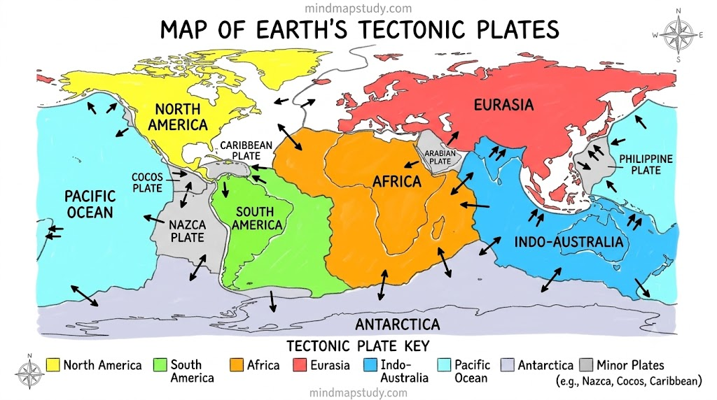
Tectonic plates are enormous, solid rock slabs that inch along at a speed of only a few centimetres each year. They are grouped into three types:
- Continental plates – carry continents
- Oceanic plates – carry ocean floors
- Mixed plates – carry both continents and oceans
Some well-known plates include the Pacific, Eurasian, African, North American, South American, Indo-Australian, and Antarctic plates.
2.3 What Drives Plate Movement?
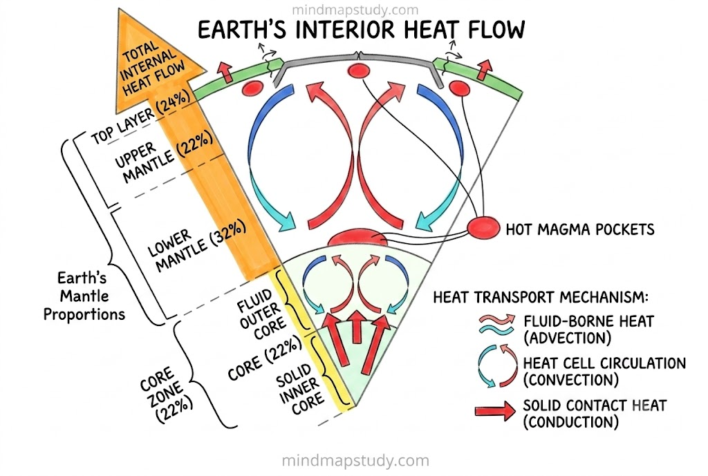
Plates move because of convection currents inside the mantle. Heat rising from the Earth’s core makes molten rock in the mantle rise upward, while cooler material sinks back down. This constant circulation pushes and drags the plates in different directions.
2.4 Plate Boundaries
The line where two plates touch is called a plate boundary. There are three kinds:
| Boundary type | Plate movement | Result |
|---|---|---|
| Convergent | Plates move towards each other | Fold mountains (e.g., Himalaya) when continental plates meet; volcanic activity and earthquakes when an oceanic plate sinks below a continental one |
| Divergent | Plates move apart | New crust forms as magma rises, creating mid-ocean ridges (e.g., Mid-Atlantic Ridge) |
| Transform | Plates slide past each other sideways | No new crust made or destroyed; mostly triggers earthquakes (e.g., San Andreas Fault) |
Plate tectonics is central to understanding how mountains, valleys, ocean basins, volcanoes, and earthquakes come about, and it also explains how continents and oceans are spread across the globe. Most volcanic and seismic activity is concentrated along plate edges, particularly around the Pacific Ocean in a belt called the Ring of Fire.
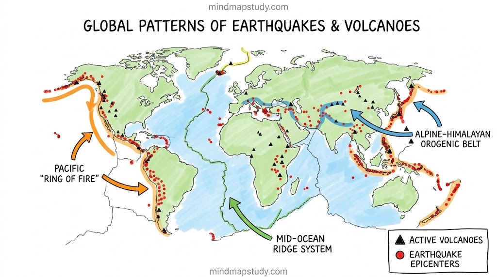
Imp note: Even before modern plate tectonics, ancient Indian texts had their own explanations for earthquakes. The Bṛihatsaṁhitā by Varāhamihira linked tremors to four elemental forces — wind, fire, thunder, and water — showing an early blend of observation and cosmology.
3. Process of Weathering and Erosion
Weathering and erosion are the two natural processes constantly chiselling away at the Earth’s surface, wearing down mountains, cutting valleys, and building plains, caves, cliffs, and deltas over long stretches of time.
3.1 Weathering
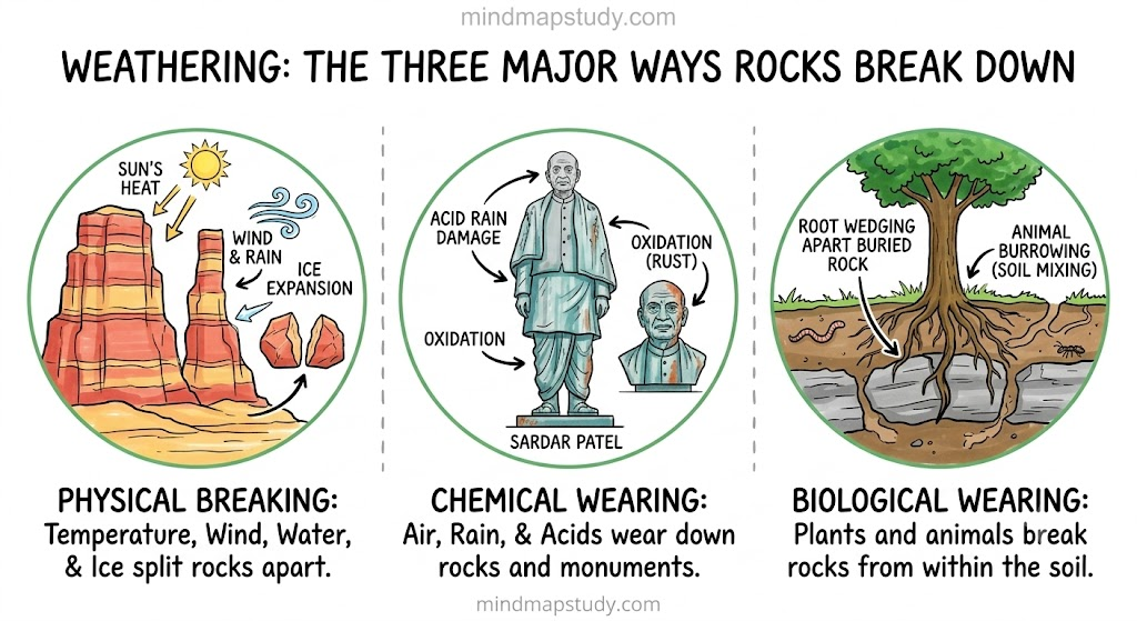
Weathering breaks rocks into smaller fragments right where they lie — no material is carried away. It happens in three main ways:
- Physical weathering – rocks crack apart due to temperature swings, frost, or wind
- Chemical weathering – minerals in rock react with water, air, or acids and turn into new substances
- Biological weathering – plants, animals, or micro-organisms break rock apart, such as roots forcing their way into cracks
3.2 Erosion
Erosion is different from weathering because it involves the movement of broken material from one place to another, carried by natural agents.
| Type | Cause |
|---|---|
| Water erosion | Rivers, rainfall, ocean waves |
| Wind erosion | Common in dry, sandy regions |
| Glacial erosion | Ice scraping and transporting rock |
| Coastal erosion | Waves wearing away the shoreline |
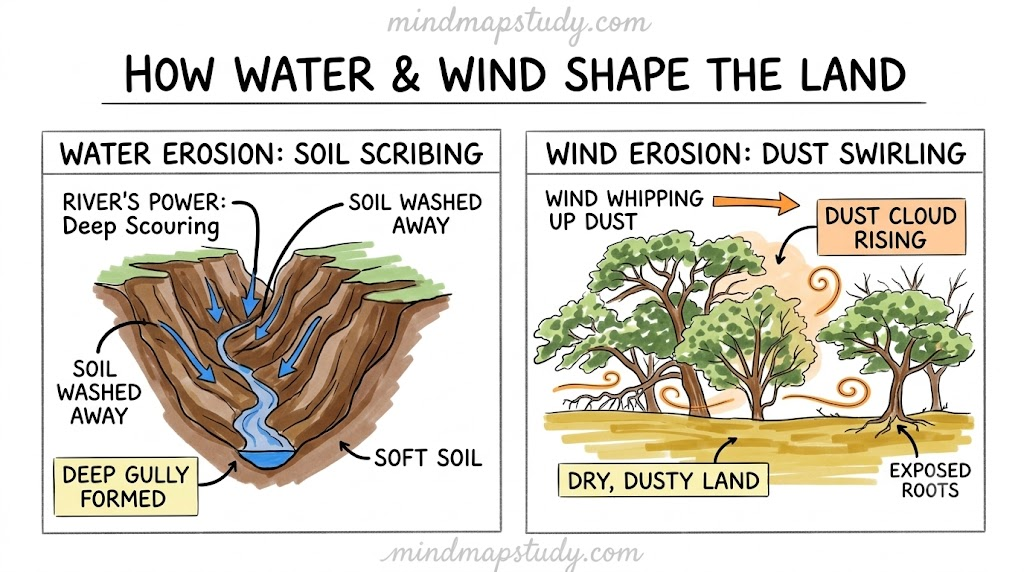
Erosion has a direct impact on people’s lives — farmers lose fertile topsoil, coastal and riverside homes can be washed away, construction and mining sites become unstable, and industries such as fishing and tourism suffer when beaches or rivers are damaged.
Imp note: Ancient water-management techniques like contouring, bunding, and terracing (used since the Sindhu-Sarasvatī civilisation) helped slow down water flow and reduce soil erosion. The Zabo farming system of Nagaland is a modern example of such integrated conservation.
4. Agents of Gradation
Agents of gradation are natural forces — running water, glaciers, wind, waves, and groundwater — that wear down high areas and fill up low ones, gradually levelling the Earth’s surface.
Imp note: Landforms have shaped human history too — fertile river plains like those of the Ganga, Nile, and Indus supported early farming societies; mountains like the Himalaya acted as both barriers and connectors (through passes like Khyber); deserts like the Thar limited settlements but encouraged trade routes such as the Silk Route.
4.1 Running Water
Rivers erode, transport, and deposit material as they flow, creating different landforms at different stages:
| Course of river | Landforms formed |
|---|---|
| Upper course | V-shaped valleys, waterfalls, rapids |
| Middle course | Meanders, oxbow lakes, floodplains |
| Lower course | Deltas, levees, alluvial fans |
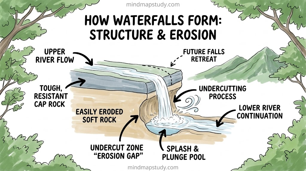
Waterfall – forms where a river drops over a steep cliff, usually where hard rock resists erosion while softer rock beneath wears away faster. Waterfalls attract tourists, support hydroelectric power generation, and are often culturally significant.
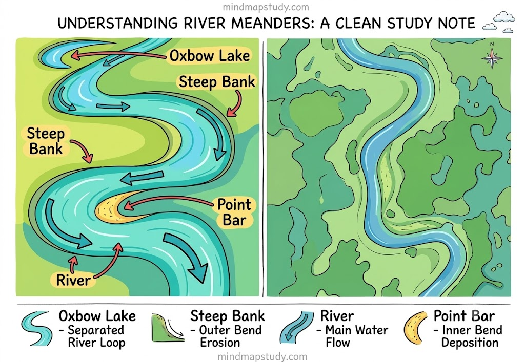
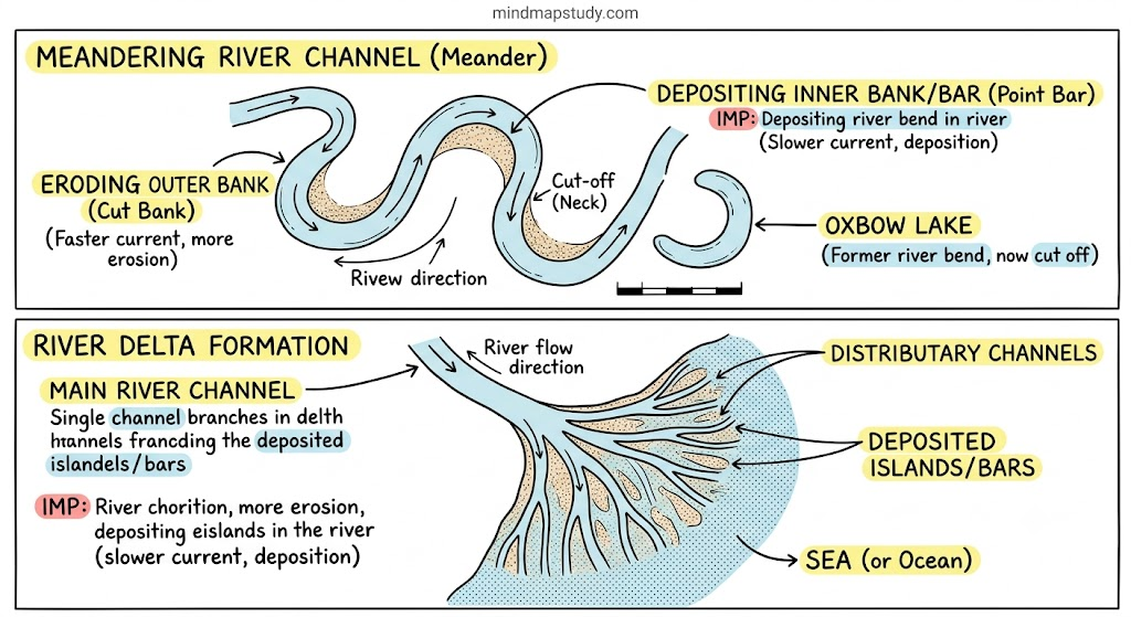
Meander – a winding bend in a river’s middle or lower course, formed as the river erodes its outer bank and deposits sediment on the inner bank. Meanders create fertile farmland, influence where villages develop, and support irrigation and navigation.
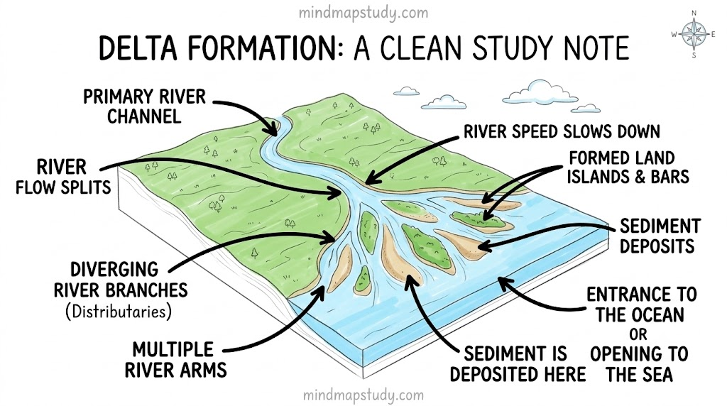
Delta – forms where a river meets a sea, ocean, or lake and drops the sediment it has carried, building up a fan or triangular landmass over time. Deltas are fertile and support agriculture, fishing, trade, and dense settlement, though they are also flood-prone.
4.2 Waves and Currents
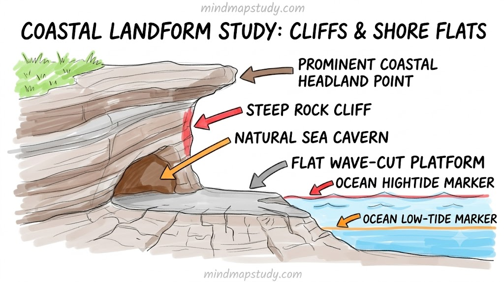
Constant wave and current action along coasts builds a variety of landforms.
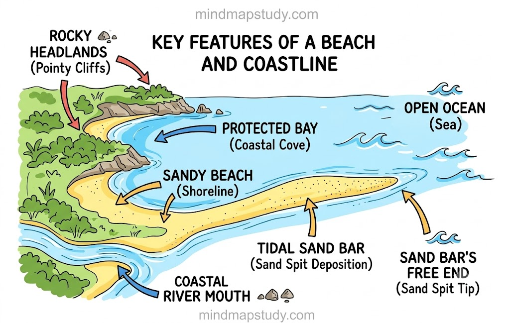
Beach – sand, pebbles, or rock deposited along a shoreline by wave action; beaches support tourism, fishing, and act as a natural buffer against strong waves.
Landforms of coastal erosion:
| Landform | How it forms |
|---|---|
| Cliff | Steep rock face formed as waves cut into the coast’s base |
| Wave-cut platform | Flat surface left behind as a cliff retreats |
| Cave | Waves erode a weak spot in rock |
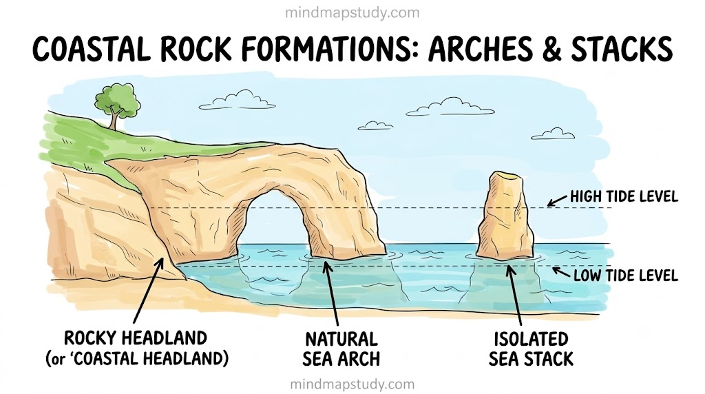
| Arch | Caves on either side of a headland join up |
| Stack | Isolated rock pillar left once an arch collapses |
4.3 Glaciers
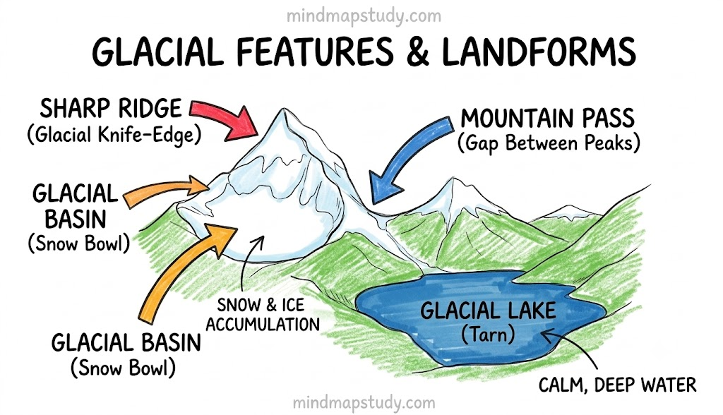
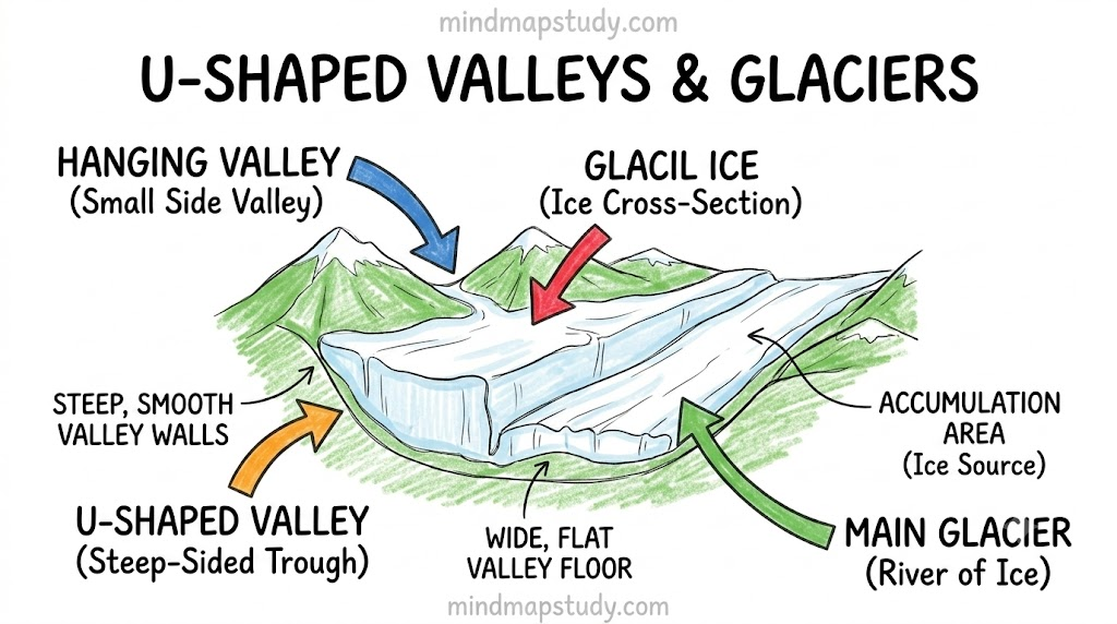
Moving glaciers carve and reshape mountain landscapes through erosion.
| Landform | Description |
|---|---|
| U-shaped valley | Formed as glaciers widen and deepen old river valleys |
| Cirque | Bowl-shaped hollow at the head of a glacier |
| Arete | Sharp ridge between two valleys |
| Hanging valley | Formed where a smaller glacier joins a bigger one |
| Fjord | Narrow, deep sea inlet formed when the sea floods a glacial valley |
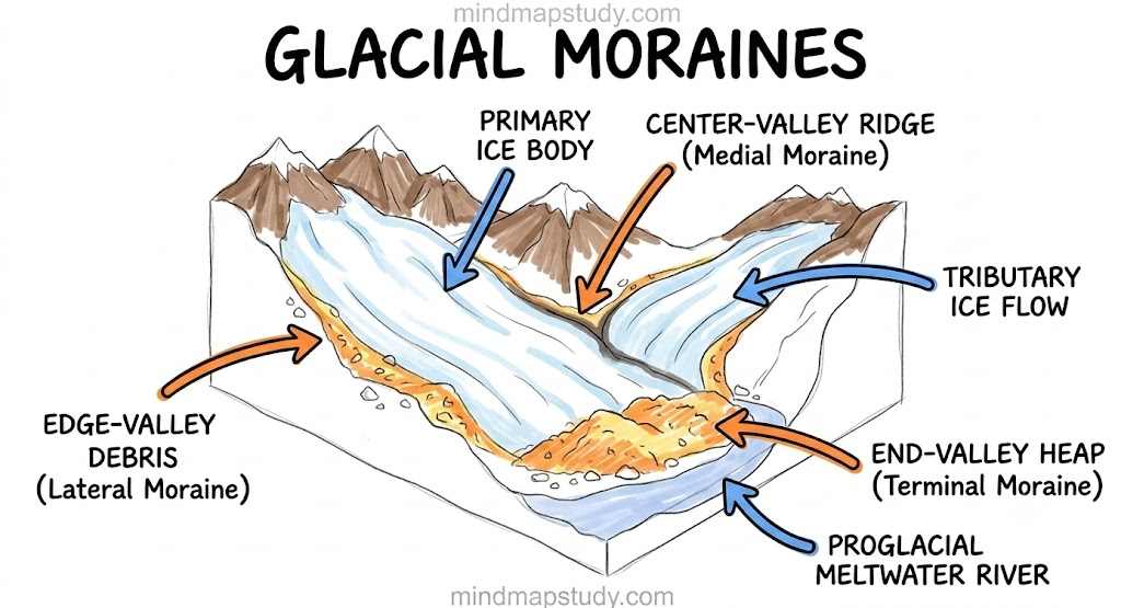
Moraines are ridges of rock, soil, and debris (called till) dropped by melting glaciers.
- Lateral moraines – along the sides of a glacier
- Terminal moraines – at the farthest point the glacier reached
- Medial moraines – formed where two glaciers meet and their lateral moraines merge
Glaciers and their landforms support agriculture through fertile soil, provide fresh water for rivers downstream, and offer opportunities for tourism such as trekking and skiing.
4.4 Wind
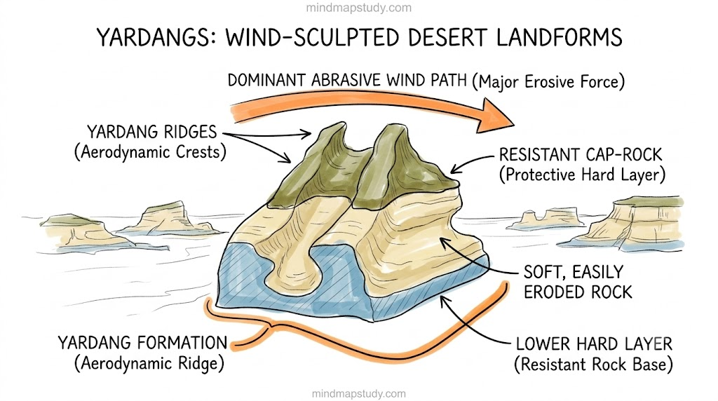
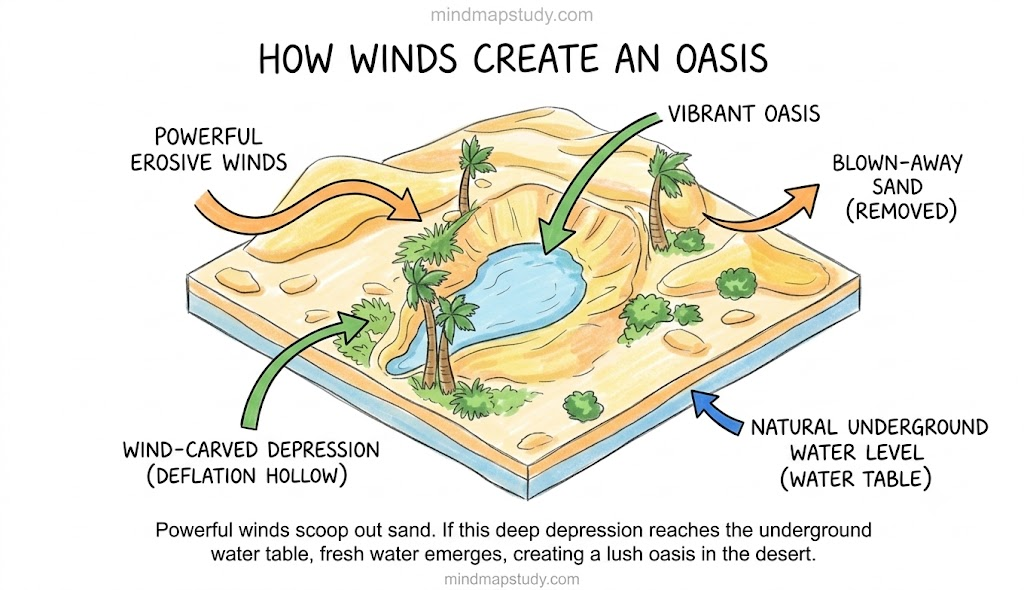
Wind erosion picks up loose sand and soil, gradually sculpting the land into distinctive shapes.
| Landform | Description |
|---|---|
| Yardang | Streamlined rock ridge carved by wind |
| Ventifact | Rock polished and shaped by blown sand |
| Deflation hollow/blowout | Shallow depression where loose material has been removed |
| Desert pavement | Flat surface left once fine particles blow away |
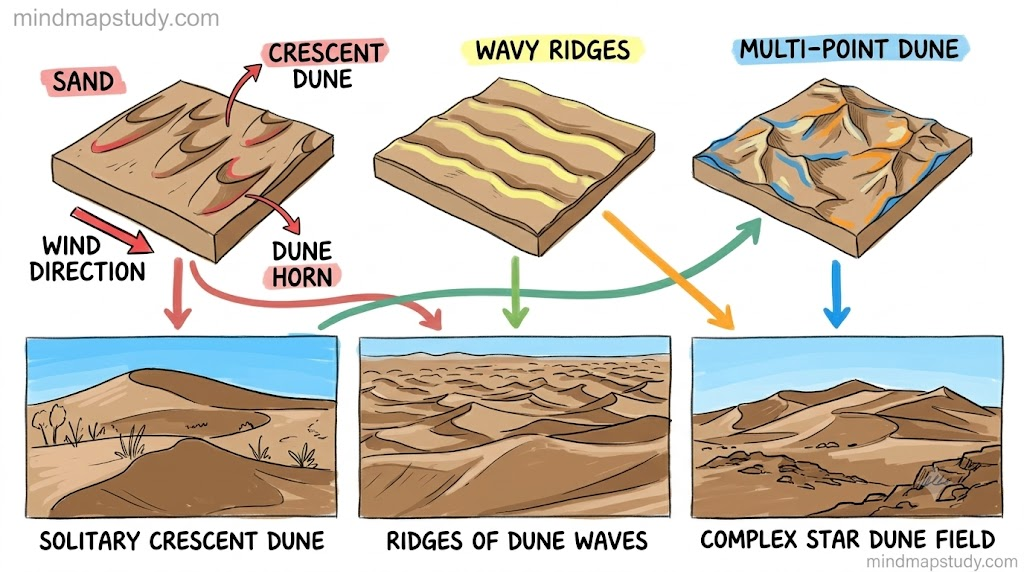
Dunes are wind-built hills or ridges of sand.
- Barchan dunes – crescent-shaped, form where sand is limited and wind blows from one direction
- Longitudinal dunes – long ridges running parallel to the wind
- Star dunes – multiple arms, form where winds blow from several directions
- Parabolic dunes – U-shaped, often held in place by vegetation
Dunes act as barriers against desertification, support tourism and adventure sports, and their sand is sometimes used in construction.
4.5 Underground Water
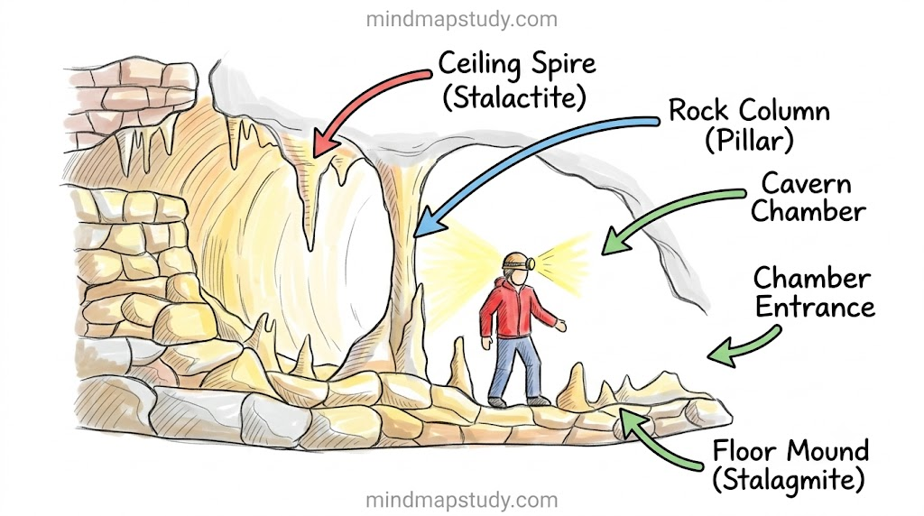
Underground water flowing through limestone or other soluble rock builds up what is called Karst topography.
| Landform | Description |
|---|---|
| Cave | Hollow space formed as acidic water dissolves rock |
| Stalactite | Icicle-like formation hanging from a cave ceiling |
| Stalagmite | Formation rising up from a cave floor |
| Sinkhole/doline | Depression formed when the ground collapses into an underground hollow |
| Underground river | River flowing through a cave system |
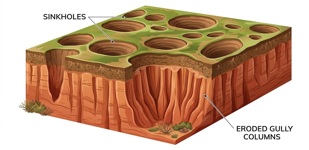
These landforms provide fresh water, tourism opportunities, and are sometimes considered culturally or religiously important.
5. Landforms and Disasters
Different landforms bring along their own set of natural hazards.
5.1 Landslides
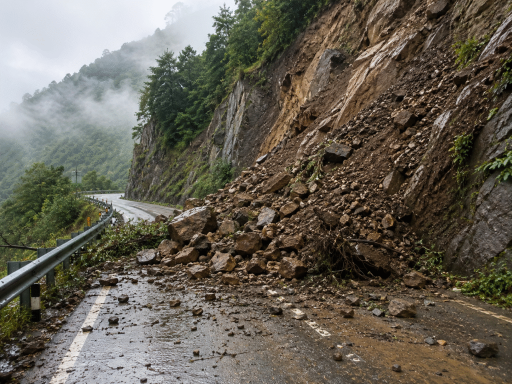
Landslides happen when slopes become unstable due to a mix of natural and human causes. Heavy, continuous rain seeps into soil and rock, adding weight and reducing grip, while earthquakes and volcanic activity can shake slopes loose. Steep terrain and weathered rock raise the risk further. Human actions such as deforestation, mining, road-building, and construction on hillsides — along with poor drainage — often tip the balance towards sudden slope failure.
5.2 Avalanches
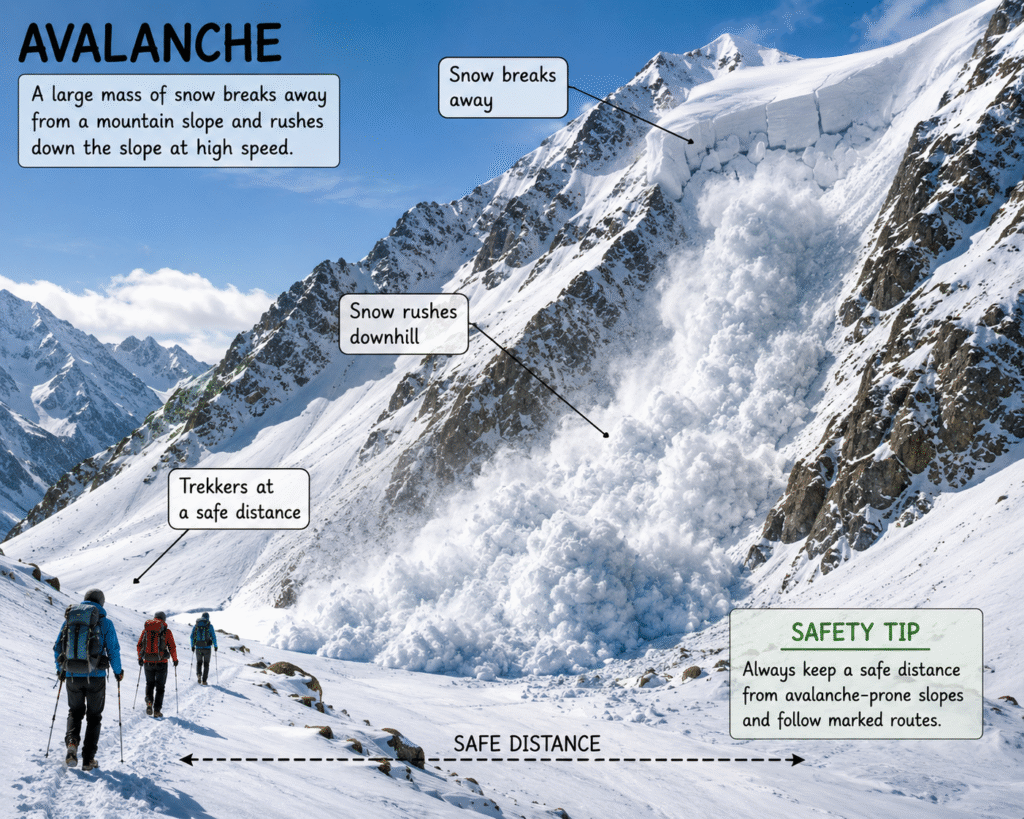
Avalanches occur when snow on a steep mountainside suddenly becomes unstable. Heavy snowfall adds weight to weak snow layers, a sudden rise in temperature can loosen the snowpack, and strong winds pile snow unevenly. Earthquakes and vibrations, as well as human activities like skiing or construction, can also set one off.
5.3 GLOFs (Glacial Lake Outburst Floods)
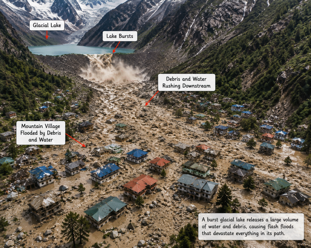
A GLOF happens when a glacial lake suddenly releases a huge volume of water. Rising temperatures melt glaciers faster, swelling these lakes and straining their natural ice or moraine dams. Heavy rain or snowfall adds extra water, while earthquakes, avalanches, or landslides can trigger a sudden dam collapse, sending a destructive flood downstream.
5.4 Dust Storms
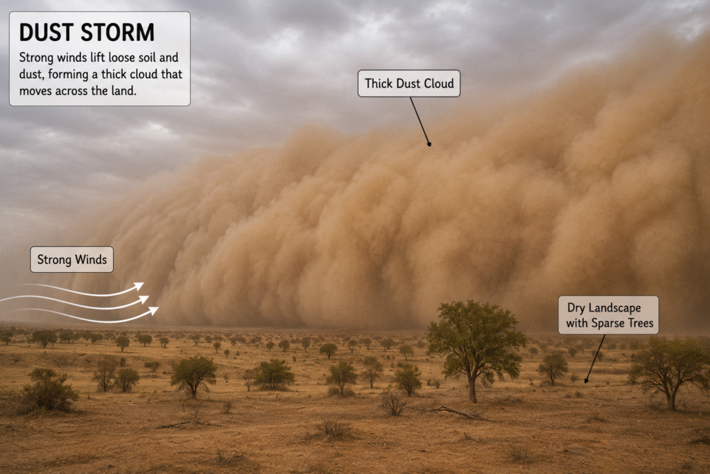
Dust storms form when strong winds lift large amounts of dry, loose soil and sand into the air. Prolonged drought dries out the ground, making particles easier to pick up. They are most common in desert and semi-arid areas, and sparse vegetation from deforestation, overgrazing, or poor farming leaves soil further exposed. Climate change is also making such storms more frequent and severe.
Before We Move On
- The Earth is made up of layers — crust, mantle, and core.
- Internal forces (earthquakes, volcanoes, folding, and faulting) drive crustal movement.
- External forces like weathering and erosion carve smaller landforms that touch human life in many ways.
- Agents of gradation — running water, waves and tides, glaciers, wind, and underground water — continuously shape the Earth’s surface.
- Landslides, avalanches, GLOFs, and dust storms are disasters tied to specific landforms.
Questions and Activities — Answers
Q1. What are the sources of energy that are required to cause movements associated with the internal forces of the Earth?
The energy driving internal Earth movements comes mainly from heat generated deep inside the planet — largely from the decay of radioactive elements in the mantle and core, along with leftover heat from the Earth’s formation. This heat creates convection currents in the mantle, which push and drag the tectonic plates, leading to folding, faulting, earthquakes, and volcanic activity.
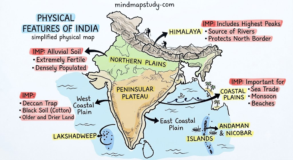
Q2. Relate various physiographic divisions you have studied in the earlier grades with various endogenic forces responsible for their origin.
- The Himalayan mountains were formed by the convergent collision of the Indian and Eurasian (continental) plates, causing folding of rock layers into towering fold mountains.
- The Northern Plains were built up by sediment deposition from Himalayan rivers, an external process linked indirectly to the uplift caused by internal forces.
- The Peninsular Plateau is an old, stable landmass shaped by ancient volcanic activity (such as the Deccan Traps) and long-term faulting and block movements.
- The coastal plains and islands owe their shape partly to volcanic activity (as in the case of some Andaman and Nicobar islands) and partly to depositional processes along the coast.
Q3. Why and where do earthquakes occur frequently? Is it possible to predict earthquakes?
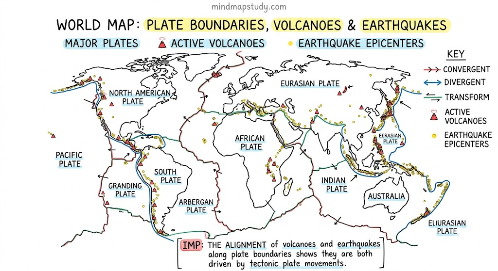
Earthquakes occur most frequently along plate boundaries, where plates collide, pull apart, or slide past one another, building up stress in the crust that is suddenly released as seismic waves. Regions like the Ring of Fire around the Pacific Ocean, the Himalayan belt, and the Mid-Atlantic Ridge are particularly prone to earthquakes because they lie along active plate margins.
At present, scientists cannot predict the exact time, location, and magnitude of an earthquake. They can identify earthquake-prone zones and estimate long-term probability using historical data and monitoring of stress build-up, but precise short-term prediction is not yet possible.
Q4. “Plate movements are responsible for the distribution of earthquakes and volcanoes.” Explain.
Earthquakes and volcanoes are not scattered randomly across the globe — they are concentrated along tectonic plate boundaries. At convergent boundaries, one plate sinking beneath another causes both volcanic eruptions and earthquakes. At divergent boundaries, magma rising to fill the gap between separating plates creates volcanic ridges. At transform boundaries, plates grinding past each other without creating magma still generate strong earthquakes. This is why the Ring of Fire, which runs along several plate edges around the Pacific, is home to a large share of the world’s active volcanoes and earthquakes.
Q5. Draw and label a diagram of a meander and a delta.
Q6. How are deforestation and erosion associated with each other? Explain.
Tree roots and plant cover normally hold soil particles together and slow down the flow of rainwater across the land. When forests are cut down, the soil is left bare and loose, making it much easier for wind and water to carry it away. Without vegetation to absorb rainfall, water runs off faster and with greater force, accelerating both water and wind erosion, degrading farmland, and increasing the risk of landslides on slopes.
Q7. Develop a plan to protect the land in your local area from erosion.
A good local erosion-control plan could include:
- Planting trees and grass cover on bare or sloping land
- Building contour trenches and bunds along hillsides to slow water run-off
- Constructing terraces on steep farmland to reduce soil loss
- Avoiding overgrazing and unplanned construction on slopes
- Maintaining proper drainage systems to prevent waterlogging and soil weakening
- Encouraging check dams on small streams to reduce water velocity and allow sediment to settle
Q8. Which disasters do you think you might experience in your region? Discuss a mitigation plan in your classroom.
This depends on your region’s landform type — for example, hilly areas may face landslides, mountainous snow regions may face avalanches and GLOFs, while dry regions may face dust storms. A mitigation plan should be discussed and prepared in class based on the specific risk of your area, covering warning systems, safe evacuation routes, avoiding construction in vulnerable zones, and community awareness drives.
Q9. Prepare a model of landforms created by underground water.
Students can build a simple model using clay, cardboard, or thermocol to show a cave system with hanging stalactites (made from clay drips or cotton) and rising stalagmites, along with a sinkhole depression on the surface above.
Q10. What precautionary measures will you take if you are staying in an earthquake-prone region?
- Ensure the building follows earthquake-resistant construction codes
- Keep heavy objects and furniture secured so they don’t fall during shaking
- Identify safe spots in each room (such as under a sturdy table) in advance
- Keep an emergency kit ready with a torch, first aid, water, and important documents
- Practice drop-cover-hold drills regularly with family or classmates
- Know the nearest open, safe area to evacuate to after the shaking stops
Q11. Prepare a map showing landform-associated disasters that happened in the current calendar year.
Students should research recent news reports and prepare a map of India or the world marking locations of landslides, avalanches, GLOFs, or dust storms that occurred during the current year, using an atlas as a reference for plotting locations.
Q12. Create a poster showing landforms that are considered to be sacred or important in your region, and add the folk stories associated with them.
This is a creative, region-specific activity — students should identify a locally significant landform (a hill, river, cave, or lake considered sacred in their area), illustrate it on a poster, and write down the folk story or legend associated with it as shared in their community.
Q13. Document a case of a disaster that hit your region in the past, highlighting its effects on various human activities.
Students should research a past disaster relevant to their own region (such as a flood, landslide, or earthquake), noting its causes, and describing its impact on farming, housing, transport, and daily life in that area.
Q14. Translate the given poster on landslide into your native language and display it in your home.
Students should translate the “Landslide: Ready Now to Stay Secure” safety poster (covering before, during, and after guidelines) into their native language and display it at home as a reminder of safety measures.
Q15. Divide the class into three groups. Each group will work on one project (water, wind, and glacier). The project should highlight the causes, impact on human life and the environment, and mitigation measures.
Each group should research their assigned agent of gradation (water, wind, or glacier), covering:
- How that agent shapes landforms
- Its positive and negative effects on human settlements, agriculture, and the environment
- Mitigation measures to manage erosion or disasters linked with that agent