
Introduction
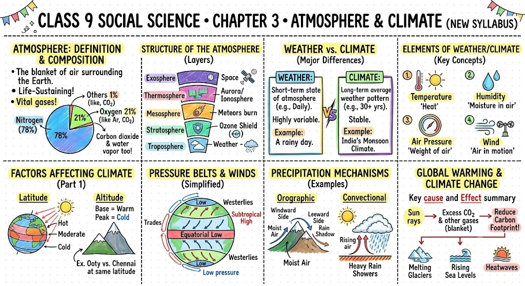
Have you ever wondered why it rains, why some places are hot while others are cold, or why we feel a breeze on a warm afternoon? The answer lies in the atmosphere — a blanket of air that wraps around the Earth and is held in place by gravity. This mixture of gases in various proportions supports all living beings on Earth. It protects us from the harmful radiation of the Sun, keeps the Earth’s temperature stable by holding some of the Sun’s energy, and drives our weather and climate every single day. This chapter takes you through the composition, layers, weather elements, monsoon, and climate change — everything that makes our atmosphere one of the most fascinating parts of our planet.
1. Composition and Structure of the Atmosphere
1.1 Composition of the Atmosphere
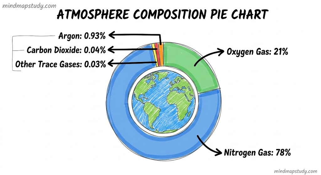
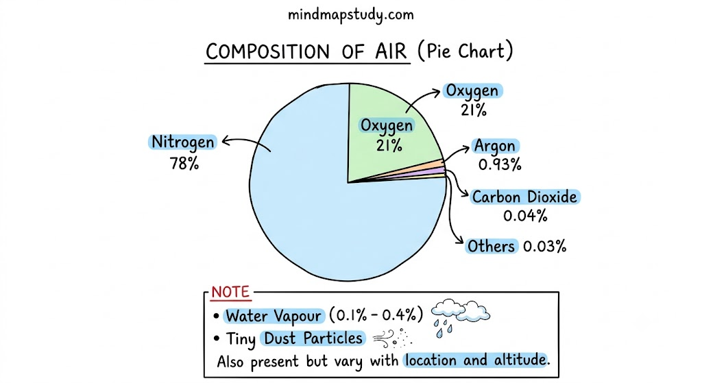
The Earth’s atmosphere is a mixture of various gases. Nitrogen and oxygen are the two primary and most abundant gases essential to life on Earth. Carbon dioxide, argon, helium, neon, krypton, xenon, ozone, and hydrogen are also present but in smaller quantities. Besides gases, the atmosphere also contains water vapour and tiny dust particles.
The amount of water vapour in the atmosphere varies but generally ranges from 0.1% to 0.4%. It plays a significant role in cloud formation and precipitation. The composition of the atmosphere also varies with altitude.
| Component | Percentage |
|---|---|
| Nitrogen | 78% |
| Oxygen | 21% |
| Argon | 0.93% |
| Carbon Dioxide | 0.04% |
| Others (He, Ne, Ozone, H, etc.) | 0.03% |
| Water Vapour | 0.1% to 0.4% (variable) |
1.2 Structure of the Atmosphere
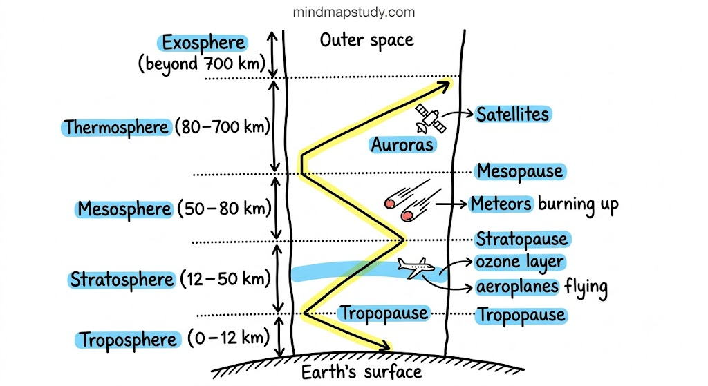
The atmosphere has a layered structure. These layers are defined on the basis of changes in temperature and density with increasing altitude. The density of air is highest near the Earth’s surface and decreases with altitude.
Imp Term — Altitude: The height of a location above mean sea level is called altitude, usually measured in metres or feet. Mean sea level is considered zero.
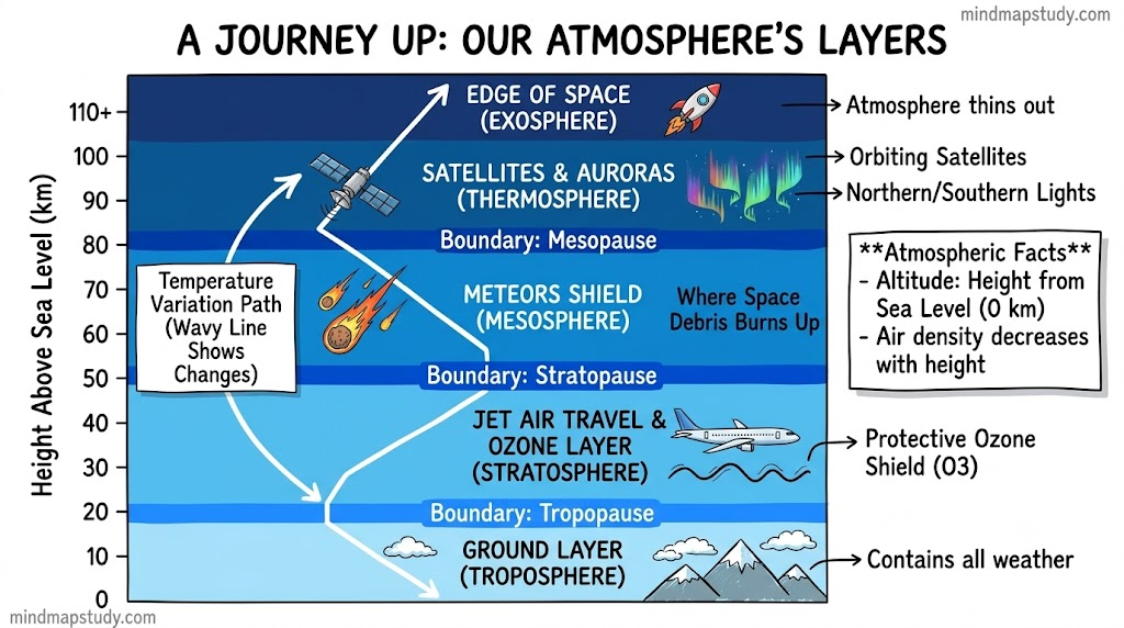
Troposphere
- The troposphere is the most important layer of the atmosphere.
- It has an average height of about 12 kilometres.
- Temperature decreases with increasing altitude in this layer.
- The air we breathe exists here, along with most of the water vapour and clouds.
- Nearly all weather phenomena — rainfall, fog, and hail — occur in this layer.
- The boundary between the troposphere and the stratosphere is a transition zone called the tropopause.
Stratosphere
- The stratosphere lies above the troposphere and extends up to 50 kilometres.
- This layer is ideal for flying aeroplanes because it is free of clouds and other weather disturbances.
- A feature of the stratosphere is that it contains a layer of ozone gas, which shields us by filtering the Sun’s harmful radiation, including ultraviolet radiation.
- The stratopause marks the boundary between the stratosphere and the mesosphere.
Mesosphere
- The mesosphere lies above the stratosphere and extends up to a height of 80 kilometres.
- Temperature decreases with increasing altitude in this layer.
- Most meteorites entering from space burn up in the mesosphere.
- The boundary between the mesosphere and thermosphere is called the mesopause.
Do Not Miss: Temperature decreases with altitude only in the troposphere and mesosphere.
Thermosphere
- In the thermosphere, temperature rises very rapidly with increasing altitude.
- Gas molecules in this layer absorb X-rays and short-wave ultraviolet radiation from the Sun.
- The thermosphere extends from 80 to 700 km.
- It helps with radio transmission by reflecting radio waves from the Earth back towards it.
- The Ionosphere is a part of the thermosphere.
- The northern and southern lights (auroras) also occur in the thermosphere.
About Aurora: The word ‘aurora’ originates from Latin, meaning ‘dawn’ or ‘morning light.’ Named after the Roman goddess Aurora, it refers to the colourful display of light seen near the poles. Solar wind — charged particles emitted by the Sun — is directed towards the magnetic poles upon reaching Earth’s atmosphere. As these particles interact with different atmospheric gases, each gas glows with a particular colour. This is known as the Aurora Borealis in the Northern Hemisphere and the Aurora Australis in the Southern Hemisphere.
Exosphere
- The exosphere is the uppermost layer of the atmosphere.
- It is characterised by very thin air.
- Light gases like helium and hydrogen float into space from this layer due to weak gravity.
- All layers together play a role in Earth’s atmospheric processes and affect its weather and climate.
Do Not Miss: The air above us exerts a significant force on our bodies, yet we do not feel it. This is because air presses on us from all sides, and our bodies exert a counter-pressure in response. The pressure inside our bodies equals the atmospheric pressure and cancels the pressure from outside.
2. Weather and Climate
Weather refers to the hour-to-hour and day-to-day conditions of the atmosphere. It can vary significantly from day to day.
Climate refers to the sum total of weather conditions and variations over a large area for an extended period of time, usually thirty years or more.
3. Elements of Weather and Climate
Various elements influence weather and climate. The major elements of the atmosphere that impact human life on Earth are temperature, precipitation, humidity, wind, and atmospheric pressure.
3.1 Temperature
- The temperature of the atmosphere varies not only between day and night but also across seasons.
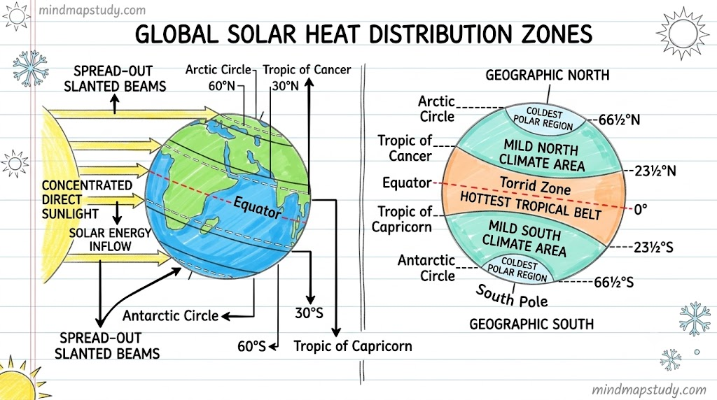
- An important factor affecting temperature distribution is insolation.
- Imp Term — Insolation: The incoming solar energy from the Sun that is intercepted by the Earth.
- Insolation decreases from the equator towards the poles. Hence, temperature also decreases from the equator towards the poles.
3.2 Humidity
- When water evaporates from land and different water bodies, it becomes water vapour.
- When the levels of water vapour in the air are high, it leads to humidity.
- Humidity refers to the presence of water vapour in the air, creating moisture.
- As the air gets warmer, its capacity to hold water vapour increases, leading to higher humidity levels.
- On a very humid day, clothes take longer to dry and sweat evaporates more slowly, leaving us feeling uncomfortable.
3.3 Precipitation
- Precipitation occurs when a part of the atmosphere becomes saturated with water vapour, which condenses and falls on the Earth due to gravity.
- It includes drizzle, rain, snow, sleet, and hail.
- The main factors that affect precipitation include prevailing winds, mountains, and seasons.
- When precipitation falls on the Earth in liquid form, it is called rain.
- Rain is the most common form of precipitation and lowers the temperature of a place.
- A long absence of rainfall results in a dry climate.
- Most of the groundwater is collected from rainwater.
3.4 Atmospheric Pressure
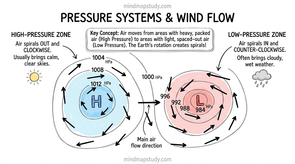
- The pressure exerted by the weight of air on the Earth’s surface is called air pressure.
- Pressure is highest at sea level and decreases with altitude.
- Horizontally, the distribution of air pressure is influenced by the air’s temperature at a given place.
| Temperature | Effect on Air | Pressure Type | Weather |
|---|---|---|---|
| High | Air heats up and rises | Low pressure | Cloudy skies and wet weather |
| Low | Air is cold and sinks | High pressure | Clear and sunny skies |
- Air always moves from high-pressure areas to low-pressure areas.
3.5 Wind
- The movement of air from a high-pressure area to a low-pressure area is called wind.
- It can be gentle or strong.
Do Not Miss: Winds are named after the direction they blow from. For example, the wind blowing from the west is called westerly.
Wind speeds and their common effects:
| Wind | Speed (km/hr) | Common Effects |
|---|---|---|
| Calm | 0–1 | Calm, smoke rises vertically |
| Light breeze | 6–11 | Wind felt on face, leaves rustle, ordinary vane moves |
| Strong breeze | 39–49 | Large branches sway, umbrellas difficult to use |
| Storm | 103–117 | Very rarely experienced, usually accompanied by widespread damage |
Local Winds — Land Breeze and Sea Breeze:
Local winds also affect the weather and climate of a place. They are essential in creating moderate climatic conditions in the coastal region.
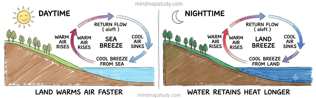
Sea Breeze: A local wind that blows from sea to land during the day, especially in the afternoon, when the land becomes relatively warmer than the sea. This creates a low-pressure region over land, and so the wind starts blowing from the sea.
Land Breeze: A local wind that blows from land to sea during the night, resulting from differential surface cooling between the land and the sea. Land cools faster than sea at night. Since the difference in temperatures and air pressure between the sea and the land is low, the wind speed is low.
4. Seasons in India
Weather conditions follow common patterns over weeks or months, dividing the year into seasons. The climate of India can be broadly classified as tropical monsoon. The Indian Meteorological Department (IMD) has recognised four distinct seasons in India:
4.1 Winter
- Generally lasts from December to early April.
- The coldest months are December and January.
- Average temperature in the north-west is around 10–15°C.
- Temperatures increase towards the equator, reaching around 20–25°C in mainland India’s south-east.
4.2 Summer or Pre-Monsoon
- Spans from April to June, or up to July in north-western India.
- In western and southern regions, the hottest month is April; in northern regions, it is May.
- The average temperature across most of inland India ranges from 32–40°C.
4.3 Monsoon or Rainy (Advancing Monsoon)
- Generally spans from June to September.
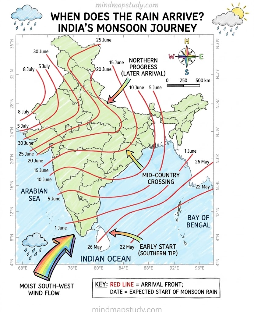
- Dominated by the humid south-west monsoon, which slowly sweeps across the country in late May or early June.
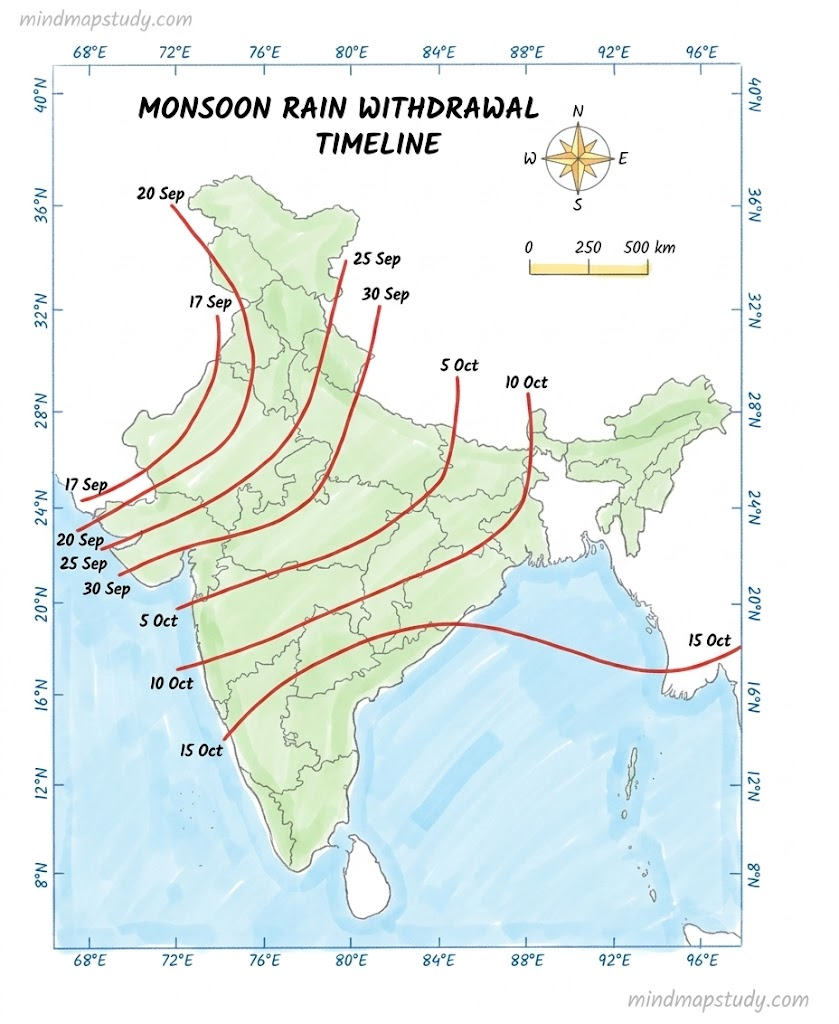
- Monsoon rain begins to recede from north India at the beginning of October.
- South India typically receives more rainfall during this time.
4.4 Post-Monsoon (Retreating Monsoon)
- Lasts from October to December.
- In north-western India, October and November are usually cloudless.
The Himalayan states, being more temperate, experience two additional seasons — autumn and spring.
Do Not Miss: Traditionally, India experiences six seasons (Rtu), each about two months long, based on the astronomical division of 12 months into six parts.
| Season (Rtu) | Months (Indian Calendar) | Months (Gregorian Calendar) |
|---|---|---|
| Vasanta | Chaitra–Vaishakha | March–April |
| Grishma | Jyeshtha–Ashadha | May–June |
| Varsha | Shravana–Bhadrapada | July–August |
| Sharad | Ashvina–Kartika | September–October |
| Hemanta | Margashirsha–Pausha | November–December |
| Shishira | Magha–Phalguna | January–February |
5. Monsoon
Imp Term — Monsoon: It refers to the seasonal reversal in the wind direction during a year.
The climate of India is strongly influenced by monsoon winds. Ancient sailors who came to India were among the first to notice this phenomenon. The Arabs, who came to India as traders, named this seasonal reversal of the wind system ‘monsoon’, derived from the Arabic word mausim, which literally means season.
Monsoon winds are seasonal winds categorised into the south-west monsoon and the north-east monsoon.
5.1 South-West Monsoon (Summer Monsoon)
- Also known as the summer monsoon or advancing monsoon.
- Characterised by winds blowing from sea to land across the Indian Ocean, the Arabian Sea, and the Bay of Bengal between June and September.
- Mainly caused by the unequal heating of land and sea.
- During summer, the landmass of India heats up faster than the surrounding oceans, creating a low-pressure area over the Indian subcontinent.
- The Indian Ocean remains relatively cooler and has high pressure.
- Moist winds move from high-pressure to low-pressure areas, blowing from the ocean towards the land and bringing rainfall.
- Accounts for most of the rainfall in the country throughout the year.
5.2 North-East Monsoon (Winter Monsoon)
- Also known as the winter monsoon or retreating monsoon.
- Occurs in India from October to February.
- During this season, the Indian landmass cools faster than the surrounding oceans, creating a high-pressure area over the land and low pressure over the seas.
- Cold and dry winds blow from land to sea.
- These winds generally do not bring rainfall to most parts of India.
- However, when the north-east monsoon winds pass over the Bay of Bengal, they pick up moisture and cause rainfall along the eastern coast of India, especially in Tamil Nadu, Andhra Pradesh, and parts of Karnataka.
- The winter monsoon is therefore important for the rainfall of the south-eastern regions of India.
5.3 Importance of Monsoon
- Most of India’s agriculture depends on monsoon rainfall, as farmers rely on rain for sowing and growing crops.
- A good monsoon ensures sufficient food production and water supply in rivers, reservoirs, and wells.
- Monsoon also affects daily life, transport, festivals, and employment, especially in rural areas.
- However, excessive rainfall can cause floods, while weak monsoons can lead to droughts.
- Monsoon greatly influences the economy, lifestyle, and livelihoods of people in India.
6. Climate Change
Climate change refers to long-term changes in weather patterns such as temperature, rainfall, and wind, caused mainly by human activities. These include burning of fossil fuels, deforestation, and industrial pollution that releases gases like carbon dioxide into the atmosphere.
These actions increase greenhouse gases such as carbon dioxide, methane, nitrous oxide, and water vapour in the atmosphere, trapping heat and raising global temperatures.
Effects of Climate Change:
- More frequent floods and droughts
- Melting of glaciers
- Rising sea levels
- Loss of biodiversity
- Threats to ecosystems, human health, agriculture, and livelihoods
- Significant impact on women, children, and vulnerable communities
Imp Term — Carbon Footprint: The total amount of greenhouse gases released into the atmosphere as a result of human activities, such as energy use, transportation, or the production of goods and services.
Tackling climate change requires collective efforts — reducing carbon footprints, using renewable energy, protecting forests, and adopting sustainable lifestyles.
7. Punjab Floods 2025: A Case Study
In 2025, Punjab experienced severe floods due to heavy monsoon rains and the consecutive swelling of the rivers Satluj, Beas, and Ravi. The floods damaged large parts of the state, including villages, agricultural fields, houses, and important infrastructure such as roads and bridges. The state suffered heavy economic losses, social disruption, and environmental damage, underlining the urgent need for improved flood management and preparedness.
Causes
Natural Causes:
- Punjab faced very heavy monsoon rains in 2025, intensified by western disturbances bringing even more moisture and rain.
- It rained not only in Punjab but also in Himachal Pradesh and Jammu and Kashmir.
- The major rivers — the Satluj, the Beas, the Ravi, and the Ghaggar — were already flowing high before the heavy rains began.
- When additional rain fell, water from the hills and local rainfall caused rivers to overflow, leading to severe flooding across many parts of Punjab.
Human-Made Causes:
- Weak and old river embankments (dhusi bandh) could not stop the rising water during heavy monsoon rains.
- People had built houses and farms too close to the rivers, reducing the natural space where floodwater could spread safely.
- Over time, silt and mud had collected in rivers and dams, reducing their capacity to hold and carry water.
- In some areas, flood warnings came late or were not clearly communicated, leaving people unprepared.
- All these factors together increased the damage caused by the floods.
Effects of the Floods in Punjab
- Many people lost their lives in the floods.
- Thousands of people had to leave their homes and move to relief camps for safety.
- Large areas of farmland were covered with water, and crops like paddy were severely damaged.
- Poultry and dairy farms were damaged and destroyed; many animals got sick or died.
- Roads, bridges, border fences, and some public buildings were also damaged.
- Standing water caused health problems, including the spread of waterborne diseases and sanitation concerns.
8. Questions and Answers
Q1. What is atmosphere? Explain its composition with the help of a pie diagram.
The atmosphere is a blanket of air surrounding the Earth, held in place by gravity. It is a mixture of gases in various proportions, essential for the survival of all living beings on Earth. It shields us from harmful solar radiation, regulates Earth’s temperature, and influences weather and climate.
| Component | Percentage |
|---|---|
| Nitrogen | 78% |
| Oxygen | 21% |
| Argon | 0.93% |
| Carbon Dioxide | 0.04% |
| Others (He, Ne, Ozone, H, etc.) | 0.03% |
| Water Vapour | 0.1% to 0.4% (variable) |
Nitrogen and oxygen are the two primary and most abundant gases. The atmosphere also contains water vapour and tiny dust particles, and its composition varies with altitude.
Q2. Draw a labelled diagram of the structure of atmosphere.
Q3. Which are the four main seasons of India?
The Indian Meteorological Department (IMD) has recognised the following four main seasons in India:
- Winter — December to early April. The coldest months are December and January, with temperatures around 10–15°C in the north-west.
- Summer or Pre-Monsoon — April to June (up to July in north-western India). Temperatures across most of inland India range from 32–40°C.
- Monsoon or Rainy (Advancing Monsoon) — June to September. Dominated by the humid south-west monsoon bringing most of the country’s annual rainfall.
- Post-Monsoon (Retreating Monsoon) — October to December. The monsoon gradually retreats; north-western India experiences mostly cloudless skies in October and November.
Q4. Why do you not feel the pressure of the atmosphere?
Although the air above us exerts a significant force on our bodies, we do not feel it because air presses on us from all sides equally. Our bodies also exert a counter-pressure in response. The pressure inside our bodies is equal to the atmospheric pressure and cancels the pressure from outside. This balance of pressures means we do not feel the weight of the atmosphere pressing down on us.
Q5. In which layer of the atmosphere do aeroplanes fly and why?
Aeroplanes fly in the stratosphere, which extends from about 12 km to 50 km above the Earth’s surface. It is suitable for flying because:
- It is completely free of clouds and other weather disturbances present in the troposphere.
- The air is calm and stable, allowing smooth flight.
- There is no turbulence caused by weather phenomena such as rainfall, fog, or storms.
This makes the stratosphere the safest and most efficient layer for commercial aviation.
Q6. Distinguish between the following:
a. The Troposphere and Stratosphere
| Feature | Troposphere | Stratosphere |
|---|---|---|
| Position | Lowest layer, starts from Earth’s surface | Above the troposphere |
| Height | Up to about 12 km | From ~12 km to ~50 km |
| Temperature | Decreases with increasing altitude | Increases with increasing altitude |
| Weather | All weather phenomena occur here | Free of clouds and weather disturbances |
| Contents | Air we breathe, water vapour, clouds | Contains the ozone layer |
| Aviation | Not suitable due to turbulence | Ideal for flying aeroplanes |
| Boundary | Upper boundary is the tropopause | Upper boundary is the stratopause |
b. The South-West Monsoon and North-East Monsoon
| Feature | South-West Monsoon | North-East Monsoon |
|---|---|---|
| Also called | Summer monsoon / Advancing monsoon | Winter monsoon / Retreating monsoon |
| Season | June to September | October to February |
| Wind direction | Sea to land | Land to sea |
| Nature of winds | Humid and moisture-laden | Cold and dry |
| Rainfall | Brings most of India’s annual rainfall | Generally dry; brings rainfall only to south-eastern coast |
| Region affected | Most parts of India | Tamil Nadu, Andhra Pradesh, parts of Karnataka |
| Cause | Land heats faster, creating low pressure over land | Land cools faster, creating high pressure over land |
Q7. Do it yourself: Table 3.3 shows the average monthly temperatures and rainfall amounts for 10 representative stations.
7.1 Re-arrange the 10 stations according to their distance from the equator.
Arranging from closest to the equator (lowest latitude) to farthest (highest latitude):
| Station | Latitude |
|---|---|
| Thiruvananthapuram | 8°29’N |
| Chennai | 13°4’N |
| Bengaluru | 12°58’N |
| Mumbai | 19°N |
| Nagpur | 21°9’N |
| Kolkata | 22°34’N |
| Shillong | 24°34’N |
| Jodhpur | 26°18’N |
| Delhi | 29°N |
| Leh | 34°N |
7.2 Find out:
a. Two stations with the most extreme climate.
The two stations with the most extreme climate are Leh and Delhi.
- Leh experiences the most extreme temperatures, ranging from as low as −8.5°C in January to 17.2°C in July, with very low annual rainfall of only 8.5 cm. Its high altitude of 3506 metres makes temperatures drop sharply in winter.
- Delhi shows a wide temperature range — from 14.4°C in January to 33.3°C in May and June — combined with uneven seasonal rainfall, making it another station with a clearly extreme continental climate.
b. Two stations influenced by retreating monsoons.
The two stations influenced by the retreating (north-east) monsoon are Chennai and Thiruvananthapuram.
- Chennai receives a large share of its rainfall in October and November (30.6 cm and 35.0 cm respectively), which is well after the south-west monsoon has retreated from most of India.
- Thiruvananthapuram also receives significant rainfall in October (27.3 cm) and November (20.6 cm) from the retreating monsoon, in addition to the south-west monsoon months.
c. The two hottest stations in the months of:
(i) February
Looking at the data for February temperatures:
| Station | February Temperature (°C) |
|---|---|
| Mumbai | 24.4 |
| Thiruvananthapuram | 27.3 |
The two hottest stations in February are Thiruvananthapuram (27.3°C) and Mumbai (24.4°C). Both are coastal stations located close to the equator, which is why they remain warm even in winter months.
(ii) June
Looking at the data for June temperatures:
| Station | June Temperature (°C) |
|---|---|
| Jodhpur | 33.9 |
| Delhi | 33.3 |
The two hottest stations in June are Jodhpur (33.9°C) and Delhi (33.3°C). Both are inland stations in northern India, far from the moderating influence of the sea, which makes them extremely hot during the pre-monsoon and early monsoon months.
7.3 Find out:
a. Why does Shillong experience more rainfall than Kolkata?
Although Shillong (24°34’N) is at a higher latitude than Kolkata (22°34’N), it receives far more annual rainfall — 225.3 cm compared to Kolkata’s 162.5 cm. The main reasons are:
- Shillong is located in the north-eastern part of India, in the path of moisture-laden south-west monsoon winds coming from the Bay of Bengal.
- Its elevated position at 1461 metres causes orographic rainfall — as moist winds are forced to rise over the hills, they cool down and shed heavy rainfall.
- Kolkata, being a plains city at just 6 metres altitude, does not experience this orographic effect.
b. Why does Delhi receive more rainfall than Jodhpur?
Delhi (29°N, 219 m) receives 67 cm of annual rainfall, while Jodhpur (26°18’N, 224 m) receives only 36.6 cm. The reasons are:
- Delhi is located to the east of Jodhpur and receives moisture-laden winds from the Bay of Bengal branch of the south-west monsoon more effectively.
- Jodhpur is situated in the Thar Desert region of Rajasthan. By the time monsoon winds reach Jodhpur, they have already shed most of their moisture over central and eastern India.
- The desert terrain and distance from the coast reduce the monsoon’s ability to bring significant rainfall to Jodhpur.
7.4 Now think why:
a. Thiruvananthapuram has an equable climate?
Thiruvananthapuram (8°29’N) has an equable climate — meaning its temperatures remain fairly stable throughout the year — for the following reasons:
- It is located very close to the equator, so it receives nearly uniform solar radiation throughout the year.
- It is a coastal city, situated at a low altitude of just 61 metres, right on the south-western tip of India.
- The sea has a moderating effect on temperature. The surrounding ocean heats up and cools down slowly, keeping the temperature of nearby land areas relatively stable.
- Looking at the data, temperatures range only between 26.2°C and 28.7°C across the whole year — an extremely small variation that confirms this equable nature.
b. Chennai has more rainfall only after the fury of the monsoon is over in most parts of the country?
Chennai (13°4’N) on the south-eastern coast of India receives most of its rainfall during October, November, and December — after the south-west monsoon has retreated from most of India. The reasons are:
- Chennai is located on the eastern (Coromandel) coast and lies in the rain shadow area of the Western Ghats during the south-west monsoon season. The Western Ghats block moisture-laden winds, so Chennai receives very little rainfall during June–September.
- However, when the north-east (retreating) monsoon winds blow from land to sea, they pass over the Bay of Bengal, pick up moisture, and then bring heavy rainfall to the eastern coast — particularly Tamil Nadu.
- The data clearly shows this — Chennai’s October rainfall is 30.6 cm and November is 35.0 cm, far higher than the south-west monsoon months.
c. Leh has moderate precipitation almost throughout the year?
Leh (34°N, 3506 m) receives very low and fairly distributed rainfall throughout the year — only 8.5 cm annually. The reasons are:
- Leh is located in Ladakh, which lies in the rain shadow of both the Himalayas and the Karakoram range. These mountain ranges block moisture-laden monsoon winds from reaching Leh.
- It is a cold desert, far from the moisture sources of the Indian and Arabian oceans.
- In winter, Leh receives some light snowfall from western disturbances, which accounts for the small but fairly even monthly precipitation figures seen in the data.
- Since precipitation occurs in small amounts across many months rather than as heavy seasonal rainfall, it appears moderate and fairly spread throughout the year.
7.5 Despite these differences across regions, can you observe any substantial evidence to conclude that the monsoons provide a very strong framework, lending overall climatic unity to the whole country?
Yes, despite the wide regional differences in temperature and rainfall across India, the monsoon does provide a strong unifying climatic framework. Evidence from the data:
- Stations as far apart as Mumbai, Kolkata, Delhi, Nagpur, and Bengaluru all show a clear and sharp rise in rainfall during June, July, and August — the south-west monsoon months.
- Even stations like Jodhpur, which receive relatively little rainfall, show their highest rainfall figures during July and August, confirming the monsoon’s reach across even the drier parts of the country.
- The temperature patterns also show a clear seasonal rhythm across stations — a hot pre-monsoon period, a cooler and wetter monsoon period, and a dry, cool post-monsoon and winter period.
- Stations on the eastern coast, like Chennai and Thiruvananthapuram, which receive less rain during the south-west monsoon, compensate during the north-east monsoon — still within the overall monsoon cycle.
- This common seasonal rhythm of wet and dry periods — driven by the monsoon system — provides a unifying climatic thread across the entire country, even though the intensity and timing of rainfall varies from region to region.
Q8. Collect pictures of houses and clothing of people from different regions of India. Examine whether they reflect any relationship with the climatic conditions or the relief of those regions.
This is an observation-based activity. Here is a framework to guide your answer:
Houses and Climate:
| Region | Type of House | Climatic Reason |
|---|---|---|
| Rajasthan (desert) | Thick-walled, flat-roofed mud houses | Thick walls keep interiors cool in extreme heat; flat roofs suit a dry, low-rainfall region |
| Kerala / coastal regions | Sloping tiled or thatched roofs, raised floors | Steep slopes allow heavy monsoon rain to drain quickly; raised floors prevent flooding |
| Ladakh / Himalayan regions | Flat-roofed stone or mud-brick houses | Low rainfall means no need for sloping roofs; thick walls provide insulation against extreme cold |
| North-eastern India | Bamboo houses on stilts | Heavy rainfall and flood-prone areas require elevation above ground level |
Clothing and Climate:
| Region | Type of Clothing | Climatic Reason |
|---|---|---|
| Rajasthan | Long robes, turbans, covered clothing | Protection from heat, dust storms, and intense sun |
| Kashmir / Himalayan areas | Wool, phiran (long woollen gown), shawls | Protection from extreme cold and snowfall |
| Kerala / South India | Light cotton clothing | Hot and humid climate throughout the year |
| Punjab / North India | Layered clothing in winter, light cotton in summer | Wide seasonal temperature variation requires adaptable clothing |
This activity shows clearly that the houses people build and the clothes people wear across India are closely connected to the climate and physical geography of each region — particularly temperature, rainfall, and altitude.