
India isn’t just a country—it’s a vast, vibrant land that grabs attention for its sheer size and growing economy. Spanning millions of square kilometers and nestled in South Asia, India’s geography shapes its identity, from towering mountains to sprawling coastlines.
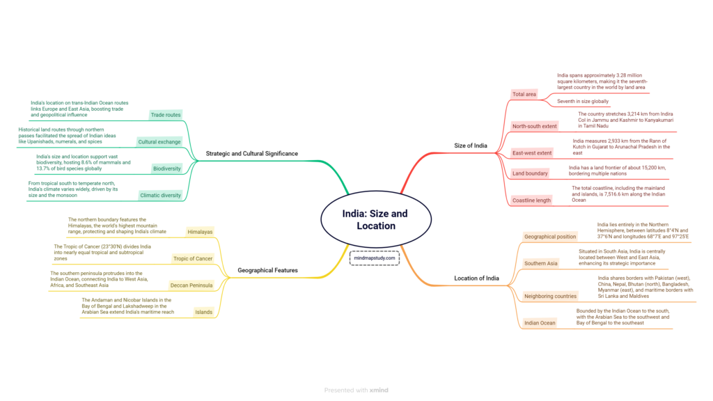
How Big Is India?
When it comes to size, India is no lightweight. Covering roughly 3.28 million square kilometers, it ranks as the seventh-largest country globally, trailing giants like Russia, Canada, and China but still outpacing many others. That’s a massive stretch of land, and its scale becomes even clearer when you measure it from end to end.
From the snowy peaks of Indira Col in Jammu and Kashmir down to the sunny shores of Kanyakumari in Tamil Nadu, India stretches 3,214 kilometers north to south. That’s like stacking over 30 football fields end-to-end! East to west, it’s just as impressive—2,933 kilometers from the salty flats of Gujarat’s Rann of Kutch to the lush hills of Arunachal Pradesh. This wide reach gives India a mix of landscapes that few countries can match.
But size isn’t just about area—it’s about borders too. India’s land frontier stretches around 15,200 kilometers, winding through diverse terrains and neighboring nations. Then there’s the coastline, a stunning 7,516.6 kilometers long, hugging the mainland and island territories like the Andaman and Nicobar Islands. That’s a lot of beachfront along the Indian Ocean, making India a key player in maritime matters. So, when people search “India size” or “largest country,” they’re tapping into a story of vastness that ranks it high but not at the top—seventh is still a big deal!
Where Is India Located?
India’s location is a geography buff’s dream. Sitting entirely in the Northern Hemisphere, it spans latitudes from 8°4’N near the southern tip to 37°6’N in the north, and longitudes from 68°7’E in the west to 97°25’E in the east. If that sounds like a mouthful, picture it as a giant rectangle tilted across South Asia, perfectly placed between West and East Asia.
This spot in southern Asia isn’t random—it’s strategic. India shares its edges with a lineup of neighbors: Pakistan to the west, China, Nepal, and Bhutan up north, and Bangladesh and Myanmar to the east. Across the water, Sri Lanka and the Maldives are maritime neighbors, linked by the Indian Ocean’s waves. Speaking of that ocean, it’s a defining feature—lapping India’s southern shores, with the Arabian Sea to the southwest and the Bay of Bengal to the southeast. Ever wondered why it’s called the Indian Ocean? India’s long coastline and central position in this watery expanse earned it the naming rights—a fact that pops up in searches like “Indian Ocean location.”
This positioning isn’t just about maps—it’s about power. India sits like a hub, connecting continents through ancient trade routes and modern shipping lanes. Its location makes it a bridge between Europe and East Asia, a detail that’s fueled its historical and economic clout for centuries.
India’s Standout Features
India’s geography isn’t just numbers—it’s alive with features that make it unique. Start with the Himalayas, the world’s tallest mountain range, guarding the northern frontier. These giants, including peaks like Everest (shared with Nepal), don’t just look impressive—they block cold winds from Central Asia, giving India its warm climate. Searches for “Himalayas India” often highlight their height and protective role, and they’re a big reason India’s weather is so distinct.
Then there’s the Tropic of Cancer, slicing through India at 23°30’N. This imaginary line splits the country into two zones: a tropical south and a subtropical north. It’s a hot topic—pun intended—in geography lessons and searches, marking where India straddles different climate bands. Down south, the Deccan Peninsula juts into the Indian Ocean, linking India to far-off places like Africa and Southeast Asia. This triangular landmass is a geological marvel, framed by the Western and Eastern Ghats.
The Andaman and Nicobar Islands dot the Bay of Bengal, while Lakshadweep sparkles in the Arabian Sea. These outposts stretch India’s reach beyond the mainland, adding to its coastal charm and strategic edge. Together, these features—the Himalayas, Tropic of Cancer, peninsula, and islands—paint a picture of a country that’s as diverse as it is vast.
Why India’s Size and Location Matter
India’s geography isn’t just pretty—it’s powerful. Its size and spot on the map have shaped its story in big ways. Take trade: India’s perch on the Indian Ocean has made it a crossroads for centuries. Ships sailing between Europe and East Asia often hugged its shores, carrying silk, spices, and more. Even today, searches for “India trade routes” point to this legacy, showing how its location boosts its global influence.
Culturally, India’s been a melting pot thanks to its borders. Ancient travelers crossed northern passes in the Himalayas, spreading Indian ideas—like zero in math or Buddhist teachings—to places like China and beyond. Spices and philosophies flowed out, while new influences trickled in. This exchange, tied to searches like “India cultural impact,” owes much to its accessible yet sheltered location.
Then there’s nature. India’s huge size—spanning climates from steamy jungles to chilly highlands—hosts incredible biodiversity. It’s home to 8.6% of the world’s mammals and 13.7% of its birds, stats that pop up in searches about “India wildlife.” The monsoon, fueled by the Indian Ocean and guided by the Himalayas, waters this diversity, making India’s climate a patchwork of wet and dry zones.
Download Free Mind Map from the link below
Visit our Main Page for Exploring Mind Maps on different topics